
 2 Videos,
IIT Delhi: Admission, Cutoffs 2026, Fees, Courses and Ranking


- Public/Government University
- Estd. 1961
 Last updated on 20 Jul '26
IIT DelhiWhat's new?
Check IIT Delhi Latest News & Notifications below:
- IIT Delhi becomes India’s highest-ranked institution at 118th globally. Education Minister Dharmendra Pradhan expresses pride over IIT Delhi's position as one of the World's Top 200 Universities.
- IIT Delhi admissions are open for its Advanced Certificate in AI Forward Deployed Engineering (FDE). Last date to apply is Oct 15, 2026.
- IIT Delhi has launched admissions for its six-month Advanced Certificate in Agentic AI programme starting Sep 26, 2026.
- IIT Delhi Admission 2026 begins for its Executive Programme in Healthcare for Industry 5.0 (Batch 3). Offered by the Continuing Education Programme (CEP), IIT Delhi, the 6-month programme is set to begin on Aug 22, 2026.
- The JOSAA 2026 counselling process has concluded for IIT Delhi admission to the BE/BTech course with the release of Round 5 seat allotment results.
- IIT Delhi and NIT Srinagar have signed an MoU under IIT Delhi–NIT Education and Research Network Initiative. The agreement aims to strengthen collaborative research, academic exchanges and postgraduate opportunities for students.
Your JEE Main 2026 Rank can help you predict your BTech College. Use Shiksha JEE Main Rank & College Predictor Now!
IIT Delhi Highlights 2026
Indian Institute of Technology Delhi (IIT Delhi) is one of India's top engineering institutions with two satellite campuses located in Sonipat, Jhajjar, and its first international campus in Abu Dhabi (UAE). Check out some of the important highlights below:
- IIT Delhi is Ranked 118th in the QS World University Rankings 2027. In the QS Asian University Rankings 2026, IIT Delhi is ranked 59th. The top engineering institute is ranked 2nd (Engineering) and 4th (Overall) as per NIRF 2025 Rankings. It is also ranked 1 under the 'Engineering' category by the India Today ranking 2026.
- The institute offers BTech, MTech, BDes, MDes, MBA, MSc, PhD, and PG Diploma programmes.
- IIT Delhi Admissions 2026 are entrance-based. Admission to the IIT Delhi Flagship BTech programme and BS programme requires a JEE Advanced qualification. Meanwhile, IIT MTech Admissions 2026 are conducted via GATE and for PhD programmes, applications are accepted via CSIR/UGC-NET. For admission at IIT Delhi, candidates are required to apply via centralized counseling portals (JoSAA, COAP, or JAM) and the official IIT Delhi application portal, iitd.ac.in.
- IIT Delhi Fees for the BE, BTech programme is INR 8 Lakh (4 Years). For ME, MTech, the tuition fee is INR 3 Lakh (2 Years).
- IIT Delhi closed its JoSAA Counselling Round 5 Cut Off 2026 at 128 for B.Tech. in Computer Science and Engineering (CSE) for General Category (Gender Neutral) candidates. Meanwhile, for BTech in Electrical Engineering the cut-off closed at 612.
- IIT Delhi Placement 2026 recorded more than 1,275 job offers, including 300+ PPOs. The Top Recruiters list includes top companies such as Google, Microsoft, Goldman Sachs, BCG, American Express, Barclays, Oracle, and PayU.
-
As per IITD overall report submitted for NIRF 2026, (BTech) UG 4-year students’ median package is INR 20 LPA. Median package for (MTech) PG students is INR 19.25 LPA.
Why Is IIT Delhi Ranked Among India's Best?
Explore official NIRF 2026 data on placements, research, faculty strength and student outcomes.
Access IIT Delhi NIRF 2026 Report

Commonly asked questions On Highlights
As of now, IIT Delhi has released the placement data 2026 that is updated till Dec 2025. As per the report, a total of 1,275 offers including PPOs have been. More than 1,140 students have been placed during IIT Delhi placements 2026. The highest package 2026 has not been released yet.
Above 300 PPOs have been already made this year, which is 33% higher as compared with 2025. 35 international offers were made in 2026. Top recruiters such as Amazon, Accenture, Google, Goldman Sachs and American Express visited the campus.
The Department of Management Studies (DMS), IIT Delhi, also known as DMS IIT Delhi offers a two-year MBA course at undergraduate courses in a full-time mode. IIT Delhi is a decent option to pursue an MBA degree. IIT Delhi ranked 4 by the National Institutional Ranking Framework (NIRF) in the Management category IN 2024. Talking about DMS IIT Delhi MBA placements 2023, the average package offered was INR 25.82 LPA and the highest package stood at INR 41.13 LPA. A placement percentage of 100% was achieved. Thus, it is a good institute for an MBA.
No, you cannot join IIT Delhi's BTech programme without JEE Advanced and JEE Main, but you can pursue BDes, MTech, MSc, MBA, MDes, PhD, executive, and certificate programmes at IIT Delhi through exams such as GATE, JAM, CAT, CEED, or direct applications.
IIT Delhi Admission 2026 without JEE Main is possible for the following:
| Programme | Entrance Exam / Selection Process | Elgibility |
| BDes | UCEED | Class 12 Qualification Through Recognised Board |
| MTech | GATE | Bachelor's degree in a relevant discipline |
| MSc / Joint MSc-PhD | IIT JAM | Bachelor's degree in a relevant subject |
| MBA | CAT + Selection Process | Bachelor's degree with required marks |
MDes | CEED | Bachelor's degree in any relevant field |
| PhD | GATE/CSIR-UGC NET/Institute Test + Interview | Master's degree in a relevant discipline |
Executive & Certificate Programmes | Direct Application | Varies by course |
IIT Delhi admission is entrance-based for all the programmes (Except for PG Diploma). For the diploma course, selection is done merit-basis. Candidates who have passed Class 12 can apply for the Indian Institute of Technology Delhi undergraduate courses. More details around the admission process of some of the courses are provided below:
- Candidates, who have passed Class 12 from a recognised board with an aggregate of 75% or above, can appear for JEE Main, followed by JEE Advanced and JoSAA Counselling to seek BTech admission at IIT Delhi.
- Admission to MTech course is based on merit in GATE exam followed by GOAP counselling.
- For MSc, aspirants need to apply with a valid score of IIT JAM and selected candidates have to further go through CCMN counselling.
IIT Delhi Courses & Fees 2026
IIT Delhi offers undergraduate, postgraduate, doctoral, and certificate programmes across Engineering, Design, Sciences, Management, and Humanities. Courses are available in full-time, part-time, and online modes.
BTech, BS, BDes, MTech, MSc, MBA, MDes, MA, and PhD come under the IIT Delhi popular programme category. The following are the course categories and specializations offered.
| BTech specialisations | Computer Science & Engineering, Electrical Engineering, Mechanical Engineering, Chemical Engineering, Civil Engineering, and Textile Technology. |
| PG programmes | MTech, MSc, MBA, MDes, and MA |
| Certificate Programmes | Statistical Inference, Computational Geometry, Advanced Textile Printing Technology, and Project Management. |
Explore engineering colleges accepting low JEE Main ranks, compare admission routes, and find the right BTech programme based on your score and preferences.
IIT Delhi Popular Courses & Fees 2026
| Course | Total tuition fees | Total Fees |
|---|---|---|
|
B.E. / B.Tech (17 Courses)
|
INR 8 L
|
INR 11.26 L - INR 11.72 L
|
|
B.Des (1 Courses)
|
INR 8 L
|
INR 11.26 L
|
|
MBA/PGDM (2 Courses)
|
INR 12 L
|
INR 13.82 L - INR 13.9 L
|
|
M.E./M.Tech (45 Courses)
|
INR 3 L
|
INR 4.82 L - INR 5.17 L
|
|
M.Sc. (25 Courses)
|
INR 30 K - INR 3 L
|
INR 2.12 L - INR 5.4 L
|
|
Ph.D. (28 Courses)
|
INR 45 K
|
INR 45 K
|
|
M.A. (2 Courses)
|
INR 30 K - INR 3 L
|
INR 2.12 L - INR 5.05 L
|
|
M.Des (1 Courses)
|
INR 70 K
|
INR 2.52 L
|
This is estimated fee information. Actual values may differ.

Commonly asked questions On Popular Programs
After completing MSc from IIT Delhi, candidates are open to placement opportunities. The median package offered to PG (2-year) candidates was INR 12.50 LPA. Further, MSc degree holders can work in different job profiles such as research scientist, teacher, biochemist, chemical analyst, junior research fellow, etc. Some of the top recruiters for MSc course graduates are mentioned in the following table:
Top Recruiters for MSc Graduates | |
|---|---|
Bhabha Atomic Research Centre | Infosys |
Wipro | Ranbaxy |
GAIL | ONGC |
HCL | ISRO |
BAARC | BHEL |
GlaxoSmithKline | Cipla |
Presently, IIT Delhi is offering 7 Certificate courses namely Digital Marketing, Data Science, Human Resource Management, Business Management, Design Thinking & Innovation, Industrial Design, Innovation and Entrepreneurship and Project Management. The college offers courses at the UG and PG levels across the Design, Management, Engineering, and several other streams. At the UG level, IIT Delhi offers B.Tech, B. Des and other courses to students. At the PG level, the college offers M.A. M.Tech, M.A. M.Sc. And other courses to students. The candidates must fill out the application form to get admission to the Certificate and other courses offered by the college. For getting admission to certificates and other courses, the candidates must follow a certain admission procedure. The candidates must fill the application form in online and offline modes and then must submit the form with the application fees.
Yes, IIT Delhi offers an Executive MBA programme through DMS. Eligibility requires a minimum of 60% aggregate in graduation or 55% for reserved categories. Applicants need a minimum of 2 years post-qualifying work experience. Specialization in Technology Management mandates a background in Engineering/Technology/Physical Sciences/Statistics/Economics/Commerce/CA/ICWAI. Selection is based on a Personal Interview.
Yes, IIT Delhi offers a two-year full-time MSc course at the postgraduate level. The programme is offered across different specialisations. IIT Delhi admission to various MSc specialisations differs. For IITD MSc admission in Chemistry is based on a valid IIT JAM score, followed by a CCMN Counselling round. For more detailed information related to the IIT Delhi MSc course, candidates are advised to contact the admission department of the institute.
IIT Delhi Admission & Application 2026
IIT Delhi offers UG, PG, and doctoral research courses, like BTech, BSc, BDes, MTech, MSc, MBA, MDes and PhD. Among IIT Delhi aspirants, BTech and MTech programmes are the most popular. The institute does not offer direct admissions. Admissions at IIT Delhi are based on entrance exams, followed by counselling or a personal interview (PI), depending on the course.
For admission to IIT Delhi's BTech and MTech programmes, candidates have to appear for JEE Advanced 2026 and GATE 2026, respectively. More details around IIT Delhi admissions are below:
- Admission to the MSc programme is possible only with a valid JAM 2026 Score.
- A valid CAT 2026 score is mandatory for admission to the IIT Delhi MBA programme.
- IIT Delhi accepts the UCEED score for admission to the BDes programme.
- CEED 2026 score is mandatory for admission to the IIT Delhi MDes programme. It's the only programme where candidates are required to appear for a Studio Test along with a Personal Interview.
IIT Delhi Admission 2026 are entrance based. The engineering institute does not offer direct admissions. IIT Delhi Application 2026 window opens through its official website, i.e. iitd.ac.in. For IIT Delhi BTech admissions, candidates are required to apply through JoSAA. IIT Delhi MTech Admissions are conducted through COAP.
Candidates are then required to fill out the IIT Delhi MTech application form through the official website. For MDes, MBA and PhD admissions, candidates are required to fill the form available on the official IIT Delhi portal.
Check out IIT Delhi admission dates for 2026 below:
M.E./M.Tech Admissions 2026
 Eligibility
- Undergraduate Degree with 60% aggregate
- 10+2 with 75% aggregate
- Accepting Exams: GATE, JEE Main, JEE Advanced
 Important dates
| Dates | Events |
|---|---|
14 Aug '26 | GATE 2027 Application Form Release Date |
21 Sep '26 | GATE 2027 Registration Last Date without late fee |
30 Sep '26 | GATE 2027 Registration Last Date with Late Fees |
MBA/PGDM Admissions 2026
Eligibility- Undergraduate Degree with 60% aggregate
- Accepting Exams: CAT
Important dates| Dates | Events |
|---|---|
Aug '26 | CAT 2026 application processTentative |
Nov '26 | CAT 2026 admit card download Tentative |
Dec '26 | CAT 2026 result announcementTentative |
B.Des Admissions 2026
Eligibility- Accepting Exams: UCEED
Important dates| Dates | Events |
|---|---|
10 Mar '26 - 31 Jul '26 | UCEED 2026 Score CardOngoing |
17 Jan '27 | UCEED 2027 Exam DATE |
Commonly asked questions On Admissions
BTech is IIT Delhi's flagship programme. Qualifying JEE Mains 2026 and JEE Advanced 2026 is mandatory for IIT Delhi BTech Admissions 2026. Meanwhile, 75% aggregate in Class 12 board exams is strictly required for IIT BTech admission 2026.
IIT Delhi BTech Seats are allotted via JoSAA counselling based on ranks and cutoffs. According to IIT Delhi JEE Advanced 2026 cutoff, the institute closed the Round 1 cut off at 123 for B.Tech. in Computer Science and Engineering (CSE) for General Category (Gender Neutral) candidates.
No, you cannot get admission to the Indian Institute of Technology IIT Delhi with CUET scores. IIT Delhi admits students on the basis of national-level engineering entrance exams. The institute considers JEE Main, JEE advanced and UCEED for UG courses. Whereas, GATE/ IIT JAM/ CEED and others are considered for PG admission.
The number of seats available for M.Tech specialisations at IIT Delhi is 1568. In the following table, specialisation-wise seat breakup is provided:
Courses | Seats |
|---|---|
44 | |
44 | |
44 | |
44 | |
M.Tech. in Molecular Engineering (Chemical Synthesis and Analysis) | 44 |
Along with the application form, certain documents have to be submitted. The aspirants are required to submit scanned copies of below-mentioned documents while filling IIT Delhi application form in online mode:
- the latest passport-size photograph
- First and last pages of Aadhar Card/ Voter ID Card/ Passport
- PAN Card
- Admission offer letter
- Entrance exam scorecard
- Qualifying degree certificate
- Qualifying exam mark sheet
- Category certificate (only in case of candidates belonging to SC/ ST/ OBC/ EWS/ PwD category)
- No objection certificate (only in case of part-time applicants)
- Sponsorship certificate/ Relieving letter (in case of full-time sponsored/ full-time working candidates)
- Medical certificate (in case of full-time candidates)
IIT DelhiStudents Ratings & Reviews
 Placements4.4
 Infrastructure4.4
 Faculty & Course4.3
 Campus Life4.6
 Value for Money4.6

IIT Delhi Cutoff 2026
IIT Delhi JEE Advanced Cutoff 2026 has been released on the official website of JoSAA, i.e., josaa.nic.in! As per JoSAA Round 5 Cut Off 2026, the IIT Delhi rank closed at 128 for CSE.
As per JoSAA Round 4 Cut Off 2026, the opening and closing rank for IIT Delhi ranged from 128 to 6151.
As per JoSAA Round 3 Cut Off 2026, the opening and closing ranks for IIT Delhi ranged from 35 to 123 for Computer Science Engineering; for Civil Engineering, the ranks ranged from 179 to 4798; and for IIT Delhi Electrical Engineering, the opening and closing ranks ranged from 403 to 593.
As per JoSAA Round 2 cutoff for IIT Delhi, the top 3 toughest BTech branches for admission were BTech in Computer Science and Engineering, Integrated BTech + MTech in Computer Science and Engineering and BTech in Mathematics and Computing Engineering, with cutoff ranks of 123, 211 and 320, respectively for General category (gender-neutral) candidates. JEE Advanced 2026 cutoff Opening and Closing Ranks represent the minimum rank required for admission to various IIT Delhi BTech programmes. The higher the candidate’s rank, the higher the chances of the candidate getting admission. Participating in JoSAA counselling 2026 is mandatory for admission to IIT Delhi.
Missed the IIT Delhi Cutoff?Explore engineering colleges accepting low JEE Main ranks and discover alternative pathways to pursue your BTech dream. |
IIT Delhi also accepts IIT JAM cutoff for admission to the MSc course. With the release of IIT Delhi IIT JAM Round 4 closing ranks, MSc in Economics turned out to be the most competitive specialisation with the lowest rank of 13 for the General AI category. The lower the rank, the higher the competition. Hence, it is considered one of the toughest MSc course to get at IIT Delhi.
Check IIT Delhi Cut Off 2026 for other programmes below:
MBA/PGDM CAT Cut Off 2025: Year-Wise percentile
 5
5
| Section | 2025 |
|---|---|
| Overall | 98.04 |
| Quants | 98.04 |
| VA-RC | 98.04 |
| DI-LR | 98.04 |
 Cut-off data is indicative and not official.
IIT JAM Round 5 Closing Rank (General-All India)
| Course | 2024 | 2025 | 2026 |
|---|---|---|---|
| M.Sc. in Physics | 157 | 135 | 171 |
| M.Sc. in Chemistry | 108 | 103 | 82 |
| M.Sc. in Mathematics | 173 | 179 | 145 |
| M.Sc. in Economics | 32 | 13 | 17 |
| M.Sc.in Biological Sciences | 541 | 676 | 627 |
JEE Advanced Round 5 Closing Rank (General-All India)
| Course | 2024 | 2025 | 2026 |
|---|---|---|---|
| B.Tech. in Computer Science and Engineering | 116 | 126 | 128 |
| B.Tech. in Electrical Engineering | 625 | 605 | 612 |
| Integrated B.Tech. + M.Tech. in Computer Science and Engineering | 204 | 186 | 212 |
| Integrated B.Tech. + M.Tech. in Mathematics and Computing | 417 | 355 | 403 |
| B.Tech. in Mathematics and Computing Engineering | 332 | 323 | 338 |
Commonly asked questions On Cutoffs
During the IIT Delhi JEE Advanced cutoff 2026, the Round 1 closing ranks varied between 123 and 6132 for BTech admission in the General category under the AI quota. So, considering the first-round closing rank, you can get a seat at IIT Delhi for BTech admission with a JEE Advanced cutoff rank of 100.
Opening and Closing rank depends on the category and quota of candidates. For general category under All India, opening rank was 574 and closing rank was 574. Cut off are different when it comes to other categories or female candidates and even domicile of home state. In All India, opening and closing rank for female candidates was 1572 and 1572. Admission to BTech in Electrical Engineering in IIT Delhi is based on the scores obtained in the entrance exam JEE. Applicants are advised to confirm what category are they applying while checking for cut offs.
The rank needed for admission at IIT Delhi for the MSc course depends on which category you belong to, which round you are applying in, and which course you have chosen, etc.
For the General AI category, the round 1 cutoff ranged from 7 to 604 for various MSc courses and their specialisations. Students can look at the table below to know the General AI category IIT Delhi cutoff 2026 for round 1. The courses are listed from the most to least competitive.
| Course | IIT Delhi cutoff 2026 |
|---|---|
| M.Sc. in Economics | 7 |
| M.Sc. in Chemistry | 76 |
| M.Sc. in Mathematics | 127 |
| M.Sc. in Physics | 133 |
| M.Sc.in Biological Sciences | 604 |
Note: Please know that other categories will have different cutoffs.
Yes, you can get into IIT Delhi with a rank of 30 if you belong to the OBC AI quota. As per the IIT Delhi BDes cutoff 2026 for the third round, the cutoff for this category was 32.
Hence, getting admission with a rank of 30 is possible for the OBC AI category. Other categories, rounds, etc., will have different cutoffs. To know the same, click here.
IIT Delhi Rankings 2026
IIT Delhi has improved its global standing from 123rd rank to 118th rank in QS World University Ranking 2027, retaining the top spot for the 2nd consecutive year. IIT Delhi is one of the top ranking engineeirng institutes in various rankings, including NIRF, QS World University Rankings, QS Asia Ranking, Times Higher Education, etc., the Indian Institute of Technology Delhi has significantly risen over the past few years. Take a look at the comprehensive IIT Delhi Rankings below:
|
IIT Delhi International Rankings 2025, 2026, 2027 |
||
|---|---|---|
|
Ranking Body |
Category |
Ranking |
|
QS World University Rankings 2027 |
World University |
118 |
|
QS World University Rankings 2026 |
World University |
123 |
|
QS World Ranking 2025 |
World University |
150 |
| QS World Rankings: Southern Asia 2026 |
Institute |
1 |
|
QS Asian University Rankings 2026 |
Institute |
59 |
|
IIT Delhi National Rankings 2025, 2026 |
||
|
Ranking Body |
Category |
Ranking |
|
India Today |
Engineering |
1 |
|
NIRF 2025 |
Engineering |
2 |
|
NIRF 2025 |
Research Institutions |
3 |
|
NIRF 2025 |
Overall |
4 |
|
NIRF 2025 |
Management |
4 |
|
NIRF 2025 |
Innovation |
7 |
| Publisher | 2025 | 2026 |
|---|---|---|
| India Today | 2 | 1 |
| The Week | – / – | 2 |

| Publisher | 2024 | 2025 | 2026 |
|---|---|---|---|
| NIRF | 2 | 2 | – / – |
| India Today | 1 | 2 | 1 |
| The Week | – / – | 1 | 2 |
| QS World University Rankings | – / – | – / – | 36 |
| Publisher | 2025 |
|---|---|
| NIRF | 4 |
Commonly asked questions On Rankings
IIT Delhi ranks amongst the top five IITs in India. IITD has ranked 2 under 'Engineering' and 4 under 'Overall' and 'Management' categories by the NIRF 2023. In the QS World University Rankings 2025, the institute has secured #150 position. Being one of the elite Engineering institutes of India, IIT Delhi has been ranked by multiple organisations under various categories such as MBA, Engineering, Research, etc. It has also ranked 4 by the NIRF 2023 under its new category 'Research Institutions'. Internationally, IIT Delhi ranked 197 by the QS World Ranking 2024 and 46 by the QS Asia Rankings 2023. It has ranked in the top 3 Engineering colleges for the last consecutive 5 years.
IIT Delhi Placements 2026
IIT Delhi Placements 2026 recorded 1,275 job offers for students. Over 300 pre-placement offers (PPOs) secured and more than 1,140 students placed, according to the ongoing 2025-26 placement season. IIT Delhi students received more than 40 international offers from multiple global organisations located in Japan, the Netherlands, South Korea, Taiwan, the United Arab Emirates, the United Kingdom, and the United States. As per IITD overall report submitted for NIRF 2026, (BTech) UG 4-year students’ median package is INR 20 LPA. Median package for (MTech) PG students is INR 19.25 LPA.
Giving IIT Delhi Placements 2026 a 5-star rating, Shiksha Reviewer Vansh Verma (B.Tech. in Electrical Engineering - Batch of 2028) says, "90% students are placed in electrical engineering. The average package is 32 LPA for placements. The top recruiter for electrical core is Texas Instruments. Many roles are offered, such as Quant trader, software developer, data analyst, core electrical engineering, and consulting, which are open to Electrical Engineering students."
IIT Delhi Top Recruiters 2026
Leading recruiters participating in IIT Delhi BTech placements 2026 are Microsoft, Goldman Sachs, Texas Instruments, Bajaj Auto, Ola Electric, and Air India.
IIT Delhi MBA Placements 2026
The IIT Delhi MBA placement report 2026 is yet to be released. As per the official 2025 placement report, IIT Delhi MBA recorded a 98% placement rate. The highest package offered was INR 43.55 LPA, while the average was INR 22.52 LPA, and the median was INR 22.5 LPA.
IIT Delhi MBA Placements 2025 Top Recruiters
IIT Delhi MBA placements' top recruiter list includes leading companies such as Accenture, Paytm, EY, PwC, Godrej, and Flipkart.
| Course | Median Salary |
|---|---|
| B.E. / B.Tech | ₹20 LPA |
| M.E./M.Tech | ₹16 LPA |
| M.Sc. | ₹15.59 LPA |
Top Recruiters

Insights on Placements
Based on 281 Student Responses
Internships and industry projects
Students can work with faculty on research projects
Employment opportunities
Many students started their own start-ups
Higher studies preferences
Majority opted in outside India
Placement support
Organized & proactive placement process
Alumni network
Strong alumni network that help with placement opportunities
Entrepreneurship cell
Very Active and resourceful, college is also involved
Overall feeling of students
Love being in college
Commonly asked questions On Placements
For BTech students at IIT Delhi, the highest international packages have historically reached up to INR 2 crore to INR 3.4 crore per annum, typically for sought-after roles in Computer Science and Quantitative Finance.
Domestic packages for top-tier roles have frequently touched the INR 1 crore mark.
The course-wise placement percentage recorded during IIT Delhi placements in recent past is presented below:
Course | Placement Percentage |
|---|---|
BTech | 90.01% |
Dual Degree (BTech + MTech) | 90.2% |
MTech | 79.32% |
MDes | 84.21% |
MSR | 80.95% |
Some of the top recruiters that visited during IIT Delhi placements include Microsoft, Rakuten Mobile, HCL Technologies, Accenture, Graviton Research Capital LLP, Brain & Company, EXL Analytics, Cisco, Jaguar Land Rover India Limited and McKinsey & Company.
A total of 1,200 offers were made and 1,150 students were placed during the Phase 1 of IIT Delhi placements 2025. Further, more than 50 international offers were made during IIT Delhi Phase 1 placements 2024-25.
As per NIRF report 2025, the placement rate recorded and median package offered during BTech placements over the past three years are presented below:
Particulars | BTech Placement Statistics (2022) | BTech Placement Statistics (2024) | BTech Placement Statistics (2024) |
|---|---|---|---|
Median package | INR 20.5 LPA | INR 20 LPA | INR 19.08 LPA |
Total students | 685 | 835 | 946 |
Students placed | 621 | 676 | 711 |
Students opted for higher studies | 64 | 50 | 49 |
IIT Delhi Scholarships 2026
IIT Delhi offers scholarships for both undergraduate and postgraduate levels based on the financial situation of the students or their academic performance. A programme-wise split of Indian Institute of Technology Delhi IIT Delhi scholarships are mentioned in the table given below:
|
Scholarships Name |
Scholarships Detail |
|---|---|
|
UG Programmes |
|
|
Institute Merit-cum-Means Scholarships |
- Offered INR 1,000 per month and tuition fee exemption - Open for 25% of students admitted under UG level in the Engineering & Technology stream - Parental income must not exceed INR 4.50 lakh |
|
Institute Merit Prizes and Certificates |
- Offered a one-time award of INR 2,500 - Given to the top 7% of students of each four-year BTech and five-year dual degree |
|
Institute Free Studentship (UG) |
- Open for 10% of students admitted - Given on the basis of income alone |
|
Scholarship for SC/ ST/ PwD Students |
- Offered tuition fee exemption and other benefits - Given to SC/ ST/ PwD students irrespective of their parents’/ guardians’ income |
|
Donor Scholarship |
- Offered through grants received from different individuals, trusts and organisations |
|
PG Programmes |
|
|
Scholarship for MSc students |
- Offered INR 1,000 per month and tuition fee exemption - Open for 25% of students admitted to the MSc programme - Parental income must not exceed INR 4.5 lakh |
|
Scholarship for MTech, MS (Research) and MDes students |
- Fellowships and scholarships instituted by industries and individuals are offered |
|
Scholarship for PhD students |
- Offered to students admitted on a full-time basis - Offered Teaching/ Research Assistantship, provided they are not getting any other equivalent fellowship |
Commonly asked questions On Scholarships
IIT Delhi provides scholarship support to students across Undergraduate and Postgraduate programmes. Undergraduate students can avail of the Institute Merit-cum-Means Scholarship, Institute Merit Prizes and Certificates, Institute Free Studentship (UG), Scholarship for SC/ST/PwD Students, and Donor Scholarships. At the Postgraduate level, the institute offers Scholarships for MSc students, Fellowships and Scholarships for MTech, MS (Research), and MDes students, along with Teaching and Research Assistantships for PhD scholars.
Yes, IIT Delhi offer equal opportunity to students to apply for scholarships. Some of the scholarships provided by the university are Institute Merit-cum-Means Scholarships, Institute Merit Prizes and Certificates, Institute Free Studentship (UG), Donor Scholarship, and others.
Yes, IIT Delhi offers merit-based scholarship to reserved categories. The Institute offers Merit-cum-Means scholarships to undergraduate students in engineering and technology. These scholarships are offered to about 25% of the students whose annual family income is upto INR 8 lakh. The present value of Merit-cum-Means scholarship is INR 4000 per month for General/OBC/EWS students on uploading of valid family income proof annually on ERP. The recipient is also exempted from paying tuition fee. For renewal of this MCM Scholarship, students need to maintain minimum CGPA and SGPA i.e. 6.0.
 4 years
Explore popular similar colleges
Students who showed interest in IIT Delhi - B.Tech also showed interest in
Want better recommendations?
There is a 90% more chance of getting best college recommendations by sharing preferences.
- Chat with our counselor
- Get your personalised list of colleges & exams matching your preferences
IIT Delhi vs Other IITs- Which is better?
IIT Delhi often gets compared with IIT Bombay, IIT Madras, IIT Kanpur, IIT Kharagpur, IIT Roorkee, IIT Hyderabad, BITS Pilani, IIIT Hyderabad, NIT Trichy, etc.
What Makes IIT Delhi Stand Out?
Location: With its location being the National Capital, students get networking opportunities, industry collaborations, internships, and access to leadership events at IIT Delhi.
Placements: IIT Delhi recorded 1,275 job offers, more than 1,140 students placed, over 300 pre-placement offers (PPOs), 40+ international offers across seven countries, as per the ongoing IIT Delhi Placements 2026. Top recruiters include Microsoft, Goldman Sachs, Texas Instruments, Ola Electric, and Air India.
Ranking: IIT Delhi is Ranked 118th in the QS World University Rankings 2027. In the QS Asian University Rankings 2026, IIT Delhi is ranked 59th. It is also ranked 2nd (Engineering) and 4th (Overall) as per NIRF 2025 Rankings. The Institute has significantly expanded its doctoral programmes and sponsored research initiatives. Between 2020 and 2025, the institute awarded more than 2,200 PhDs, reflecting its growing research output and global collaborations.
Unique Programmes: IIT Delhi offers unique programmes across Engineering and Technology, Management, Design, Public Policy, Sciences and Humanities.
Which Is Better: IIT Delhi or IIT Bombay?
There is no universal answer. Your priorities will help you make the right choice!
• Choose IIT Delhi if you prioritise research opportunities, policy exposure, interdisciplinary learning, and the advantages of studying in New Delhi.
• Choose IIT Bombay if campus culture, alumni network, and technology entrepreneurship are your primary considerations.
For Computer Science and other highly sought-after branches, compare the latest JoSAA cutoffs, placement trends, and curriculum before making a decision. Still confused? Compare Here!
IIT Madras vs Bombay vs Delhi - Which one is better? Check out the videos to make a better choice!
Compare IIT Delhi with other similar colleges
| College | Median Salary | Total Tuition Fees | Ranking |
|---|---|---|---|
| ₹ 19.08 LPA - 24.3 LPA | ₹ 8 L | #2 NIRF, 2025 | |
| ₹ 17.92 LPA - 19.63 LPA | ₹ 8 L | #3 NIRF, 2025 | |
| ₹ 15 LPA - 46 LPA | ₹ 8 L | #1 NIRF, 2025 | |
| -/- | ₹ 5 L | #9 NIRF, 2025 | |
| ₹ 14 LPA - 19.76 LPA | ₹ 8 L | #5 NIRF, 2025 | |
| ₹ 19.4 LPA | ₹ 8 L | #4 NIRF, 2025 |
 Compare
Commonly asked questions On Comparisons
The JEE Advanced cutoff for 2026 has been released for Round 1. For BTech in Chemical Engineering, the JEE Advanced first-round closing ranks were 2649 and 2750 for IIT Delhi and IIT Bombay, respectively, for the students belonging to the General AI quota.
For CSE admission at IIT Gandhinagar, the first round closing rank stood at 2144. Therefore, regardless of the branch you get, IIT Delhi and IIT Bombay are always considered to be better options due to their brand value, academics, and placements.
In case your preference is only CSE, IIT Gandhinagar is not a bad option, as it is also known for its academics and faculty. Plus, the CSE branch has better placement opportunities. To make your decision, other aspects, such as the ranking and average package for IIT Delhi, IIT Bombay, and IIT Gandhinagar, are tabulated below:
| College | NIRF Ranking (2025) | Average Package |
|---|---|---|
| IIT Delhi | 2 | INR 21.9 LPA (2025 overall) |
| IIT Bombay | 3 | INR 26.45 LPA (2026 overall) |
| IIT Gandhinagar | 25 | INR 23.21 LPA (CSE for 2025) |
The course outline of mechanical in IIT Delhi or IIT Bombay is similar and is quite well aligned with the course structure of top ranked international universities and the mechanical is one of the most desired and demanded branches in the IITs. The universities stand on similar QS ranking level and the facility and quality of infrastructure on average is almost the same in both the campuses, IITB has a lake, a pretty larger campus than that of IITD whereas IITD stands in a very desired location of Delhi ( in Hauz Khas) which stands very close to the international airport and various railway stations and is comparatively very green and clean than the outer Delhi. The trends of placement or students going for further studies differ very less and if you are really relying on placements to be a deciding factor, you'll still be in doubt. If we look at the opening and closing ranks of the department in both the colleges, the mechanical in IITB opens before it starts at IITD and also closes some numbers before, but the range is quite same. Many people choose IITB for its past trend or some local variables and similarly people also choose IITD if they aspire to go for civil services as Delhi is the hub for the preparation for UPSC and other civil services and again the accessibility of the nearby regions. I'd say both of the campus stand on the same level if the department is considered, the selection is totally depend on the individual depending on the local variables that affects him/her.
IIT Delhi has been ranked better than IIT Kanpur. Candidates can also look at the ROI calculated based on fee and average package offered to take a decision. The following table presents a comparison between the two institutes:
MTech Institutes | NIRF Ranking 2023 | Total Tuition Fee |
|---|---|---|
IIT Delhi | 2 | INR 3 Lacs - INR 8.7 lakh |
4 | INR 20,000 - INR 8 lakh |
NOTE: The fee mentioned above is taken from an unofficial source. Hence, is indicative.
IIT Delhi CAT Cutoff 2025 has been released for admission to the MBA course. The Institute does not release the final admission CAT cutoff publicly and is only accessible through account login to those candidates who appear in the CAT exam. However, going by the year-wise cutoff trends, the IIT Delhi MBA Cutoff 2025 showed that the overall CAT percentile among the General AI category candidates is 98.04.
On the other hand, the estimated overall section cutoff percentile for IIT Bombay was 90 for admission to the MBA course. This indicates IIT Delhi's popularity for MBA among the aspirants.
IIT Delhi Application Process 2026
IIT Delhi Admission 2026 are entrance based. The engineering institute does not offer direct admissions. IIT Delhi Application 2026 window opens through its official website, i.e. iitd.ac.in. For IIT Delhi BTech admissions, candidates are required to apply through JoSAA. IIT Delhi MTech Admissions are conducted through COAP. Candidates are then required to fill out the IIT Delhi MTech application form through the official website. For MDes, MBA and PhD admissions, candidates are required to fill the form available on the official IIT Delhi portal.
IIT Delhi Application 2026 Latest Update
- For IIT Delhi MSc Admission 2026, the IIT JAM 2026 fifth admission list might be released in the first week on July.
Get complete details on IIT Delhi Admissions 2026 here!
Commonly asked questions On Application Process
IIT Delhi admission 2026 is currently open for various courses. The application process at IIT Delhi is conducted online. Students can check the list of documents required for admission below:
- Class 10 and Class 12 marksheets
- Bachelor's degree certificate & marksheets (for PG courses only)
- Master's degree certificate & marksheets (for PhD courses only)
- Entrance exam scorecard (JEE/GATE/IIT JAM/UCEED/CAT/CEED)
- Work experience certificate (if available)
- Passport-size photograph
- Scanned image of the signature
- OBC-NCL Certificate (if applicable)
- Copy of Income & Asset certificate for EWS (if applicable)
The total seat intake for the IIT Delhi MSc course is 254. Given below is the specialisation-wise seat intake for IIT Delhi MSc course:
IIT Delhi MSc Seat Intake | |
|---|---|
Specialisations | Seat Intake |
Cognitive Science | 25 |
Economics | 25 |
Chemistry | 68 |
Mathematics | 68 |
Physics | 68 |
Yes, participating in JoSAA counselling is mandatory to get a BTech seat in Indian Institute of Technology, Delhi. Students must first pass JEE Advanced exam. Then students must register on the official portal for counselling, for final seat allotment.
Candidates seeking admission to MBA course at IIT Delhi must visit the official website of the DMS IIT Delhi to apply online. IIT Delhi MBA admission to General and Telecommunication Systems Management is based on a CAT score. The final selection is based on candidates' performance in the GD & PI rounds.
IIT DelhiOther Popular IITs
IIT Bombay - Indian Institute of Technology
 MumbaiESTD 1958
 4.6(563 reviews)
IIT Madras - Indian Institute of Technology
ChennaiESTD 19594.5(371 reviews)IIT Kharagpur - Indian Institute of Technology
KharagpurESTD 19514.5(712 reviews)IIT Roorkee - Indian Institute of Technology
RoorkeeESTD 18474.4(609 reviews)IIT Hyderabad - Indian Institute of Technology
HyderabadESTD 20084.4(147 reviews)IIT Kanpur - Indian Institute of Technology
KanpurESTD 19594.6(436 reviews)IIT Guwahati - Indian Institute of Technology
GuwahatiESTD 19944.5(400 reviews)Indian Institute of Technology, BHU, Varanasi
VaranasiESTD 19194.3(645 reviews)IIT Patna - Indian Institute of Technology
PatnaESTD 20084.2(235 reviews)IIT Dhanbad (ISM) - Indian Institute of Technology (ISM)
DhanbadESTD 19264.2(614 reviews)IIT Indore - Indian Institute of Technology
IndoreESTD 20094.2(123 reviews)IIT Mandi - Indian Institute of Technology
MandiESTD 20094.3(99 reviews)IIT Delhi Campus & Facilities 2026
IIT Delhi offers modern infrastructure and amenities supporting academic, research, student life, and sports. Spreading across 320 acres of land, the engineering institute has a 24/7 central library, advanced laboratories, sports complexes, hostels, recreation centres, and robust IT infrastructure.
IIT Delhi Campus Highlights
- Fully air-conditioned lecture theatres with LCD projectors
- 24/7 Central Library with over 3 lakh resources
- High-speed campus-wide Wi-Fi and LAN connectivity
- Olympic-size swimming pool and multi-sport facilities
- Department-specific advanced laboratories
- On-campus hospital and healthcare services
- Banking, guest house, and convenience store facilities
How are IIT Delhi Hostels?
IIT Delhi hostel accommodation has been reviewed as “decent” and “well-maintained” by Shiksha Reviewers. The institute provides hostel facilities for male and female students separately. There are 5 hostels for girls and 12 hostels for boys at IIT Delhi. For first-year BTech students, 3-seater rooms are typically available. Meanwhile, 2-seater rooms are also available due to the varied infrastructure across the 17 hostels.
Can Parents Visit IIT Delhi Hostels? What's the Curfew Time? Get the official IIT Delhi Hostel Rule Book covering room allocation, visitors, silence hours, hostel fees and stay permissions.
Download IIT Delhi Hostel Guide
IIT Delhi's total hostel fee consists of one-time charges, recurring semester-wise charges, and centralized A/C charges (for new hostel residents only):
| Fee Component | Amount (INR) | Frequency | Remark |
|---|---|---|---|
|
Seat Alotment |
7,000 | One Time | Payable at the time of Hostel Allotment |
| Security Deposit | 15,000 | One Time | Refundable |
| Recurring Hostel Charges | 36,000 | One Time |
Includes mess charges, utilities, and other facilities for both old and new hostels |
| Centralised A/C Charges (Single Occupancy) | 15,000 | Per Semester | Applicable only to Residents of New Hostel |
| Centralised A/C Charges (Double Occupancy) | 7,500 | Per Semester | Applicable only to Residents of New Hostel |
Talking about the food and facilities at IIT Delhi, another Shiksha Reviewer mentioned that the rooms might feel a bit cramped up and as IIT Delhi was established in the 1960s, the infrastructure is also not really high-tech. However, he has mentioned that IIT Delhi hostel food is tasty as compared to other college hostels.
Wondering if Hostel Compulsory in IIT Delhi? No, staying at the IIT Delhi hostel is not compulsory. Students staying within a 15km radius of the institute are not offered hostel accommodation.
Additional Campus Facilities
Students at IIT Delhi also benefit from:
- Gymnasium and recreation block
- Swimming pool
- Music room
- Club building
- Amphitheatre
- Stationery and convenience stores
- Xerox and STD/ISD/PCO facilities in hostels
- On-campus bank and ATMs
- Guest house and waiting rooms for visitors and parents
Library
Cafeteria
Hostel
Sports Complex
Labs
Insights on Infrastructure
Based on 280 Student ResponsesSports facilities
Multiple sports grounds & coaching present
College events
Busy calendar with more than 3-5 weekly events
Mess food
Mess and Cooking arrangements are Hygienic
Attendance policy
Incomplete attendance invites penalty
Dress code
Students can wear whatever they want
Additional expenses
Books
Consequence of rules violation
Rule breakers are let off with a warning
Outside movement of girl students
Not at all restricted
Commonly asked questions On Infrastructure
The IIT Delhi campus is spread across 325 acres. It is divided into four areas for administrative and logistical purposes. Thus, the campus has a West Campus (hostel area), East campus (residential area), Main Administrative Building and Academic area. IIT Delhi infrastructure advancements and operations are taken care by a dedicated Infrastructure team that works under the administrative unit. In addition, it also keeps coming up with new projects for the advacement of the IIT Delhi infrastructure.
IIT Delhi library system comprises a central library and departmental libraries. The library houses a collection of 1.94 lakh books, 1.03 bound volumes of journals, over 26,000 standards and 2,200+ microfilms among others. It also has video cassettes, CDs, and online electronic journals. IIT Delhi offers various facilities to students like a cafeteria near the academic buildings and a South Indian food court (Southy) in the boys' hostel area. IIT Delhi is known for its sports and hence it offers several practising courts to the students, including badminton, tennis, volleyball and basketball courts, cricket, etc.
South Indian students are considered very knowledgeable by North Indian students. IIT Delhi provides a platform for students belonging to diverse cultures. There is no cultural discrimination at IIT Delhi. In the beginning, a South Indian student may find language differences here due to which there can be communication barriers but this difference can be eradicated with the help of the English language which is a kind of secondary language to most of the North Indians studying here. Opportunities available in the college are equal for everyone. It depends on the student how he/she takes the situation.
IIT DelhiColleges/Departments

| College/Departments | Rating |
|---|---|
| DMS IIT Delhi | 4.4 (44 Reviews) |
Top online courses you might be interested in
IIT Delhi Notable Alumni
The alumni of IIT Delhi are placed across different sectors such as Engineering, Marketing, Human Resources, etc. Apart from this, IIT Delhi's alumni have also been active participants in our society and represent the country nationally and internationally as social workers and entrepreneurs. Some of the notable alumni who have added value to the system of IIT Delhi are listed below:
|
Alumni Name |
|
|---|---|
|
Hitesh Oberoi (BTech CSE, 1994) is the Co-Promoter, Managing Director and CEO of Info Edge India Ltd., the parent company of Naukri.com, 99acres, Jeevansathi, and Shiksha.com, with investments in leading startups such as Zomato and Policybazaar. IIT Delhi Distinguished Alumnus Award (2021) was awarded to Hitesh for his contribution to India's internet and startup ecosystem and has over two decades of leadership experience in the digital industry. |
|
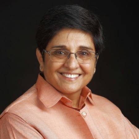
| Kiran Bedi is the first woman in India to join the officer ranks of the Indian Police Service (IPS), the 24th Lieutenant Governor of Puducherry from 2016 to 2021. She pursued her PhD degree from IIT Delhi's Department of Social Sciences |
 |
| Chetan Bhagat is an Indian bestseller author and columnist. Five of Chetan Bhagat's novels have also been adapted into Bollywood films. He graduated from IIT Delhi as a Mechanical Engineer. |
 |
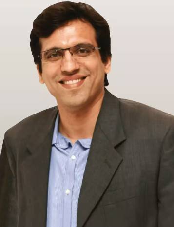
| Sachin Bansal is an Indian entrepreneur who is best known as the Co-founder of Flipkart. He is also the 86th richest person in India. Sachin Bansal attended IIT Delhi and completed a BTech degree in Computer Engineering in 2005. |
 |
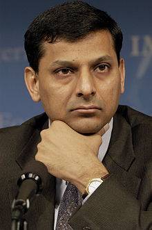
| Raghuram Govinda Rajan (also known as Raghuram Rajan) is an Indian economist and the 'Katherine Dusak Miller Distinguished Service Professor of Finance' at the University of Chicago Booth School of Business and served as the 23rd Governor of the Reserve Bank of India. |
 |
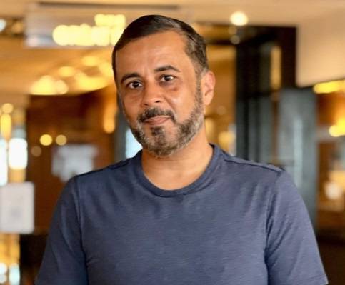
| Deepinder Goyal (Integrated MTech, Mathematics & Computing, 2005) is the Founder and CEO of Zomato, one of the world's leading food-tech companies operating across 500+ cities in India and multiple international markets. He received the IIT Delhi Distinguished Alumnus Award (2020) for his entrepreneurial excellence in building a global food delivery and restaurant technology platform serving millions of users. |
 |
| Sameer Gehlaut is an Indian businessman. He is the founder and chairman of the Indiabulls Group. He graduated in BTech Mechanical Engineering from IIT Delhi in 1995. |
 |
IIT Delhi FAQs
Do not choose IIT Delhi with low JEE Rank. Right BTech branch is important for a successful fast-tracked engineering career such as software developer, data scientist, or tech entrepreneur. Choosing a less popular engineering branch just for an IIT tag is often proved as a bad decision due to less placement opportunities.
Choose IIT Tag over a popular BTech branch in a private university only if you are interested in the core subject you are getting or want to pursue higher studies in the same field.
According to Shiksha counselling data, 85% of candidates appearing for JEE Mains choose private BTech colleges to fulfil their CSE engineering dream.
Yes, IIT Delhi is a good institute for MSc aspirants. The institute has got a good overall rank from NIRF in the 2023 rankings. It has been ranked at the third spot among top colleges in the country. Moreover, IIT Delhi also provide placements support. As per its 2023 placement report, the median package offered to PG (2-year) candidates was INR 12.50 LPA. Some of the top companies that participate in its placements drive are Microsoft, Cisco, Accenture, etc.
For IIT Delhi PhD admission, candidates need to meet the minimum eligibility criteria set by the institute. Master degree in Engineering/ Technology/ Science/ Humanities or equivalent in relevant stream with a CGPA of 6.00 on a 10-point scale or 60% aggregate is the basic eligibility criteria for PhD admission. Eligible candidates can apply by filling out the application form by visiting the official website. The selection is based on merit in CSIR-NET/GATE followed by an interview round.
Candidates who meet the course-specific eligibility criteria and have a valid GATE score can apply. Aspirants can complete the application form through the IIT Delhi official website. This is for M.Tech full-time programmes. For part-time/sponsored full-time courses, eligible candidates can register directly at the official website. Admission to part-time M.Tech is based on a written exam and interview round conducted by the institute.
IIT Delhi faculty are PhD, degree, and diploma holders. IIT Delhi faculty are well-qualified and are industry experts. Some of the Department of Applied Mechanics faculty members' details are mentioned below:
| Faculty Name | Faculty Details |
|---|---|
| Santosh Kapuria | Head, Applied Mechanics |
| Puneet Mahajan | PhD (Montana State) TRIPP Chair Professor |
| S.V. Veeravalli | PhD (Cornell) Professor |
The IIT Delhi UCEED cutoff 2026 has been released, wherein the admission closed at a cutoff rank of 28 for the General AI category. The Indian Institute of Technology Delhi offers a four-year full-time programme at the undergraduate level. IIT Delhi B.Des admission is based on candidates' performance in the UCEED entrance exam, followed by a counselling process.
Yes, any candidate who has passed BE/ BTech/ MSc or equivalent with a minimum 60% aggregate are eligible to apply for IIT Delhi M.Tech programme. Aspirants must also qualify GATE for admission to MTech. Aspirants with a score equal to or more than the cutoff also have to go through a counselling round. Once selected, aspirants have to pay a course fee to confirm their seat in the institute.
DMS, IIT Delhi accept MBA applications via online mode. Aspirants fulfilling the eligibility criteria and having a valid CAT score shall apply. Further, the steps to be followed for online application form filling are:
Step 1: Visit the DMS IIT Delhi official website by clicking on the ‘Admission tab’ in the menu bar.
Step 2: Select the course and fill out the application form with the valid CAT/GATE/CSIR/UGC NET/ICAR/ICMR score.
Step 3: Payment of the application fees through a credit card/debit card or net banking.
NOTE: The admission application processing fee for MBA is non-refundable.
Read more: CAT Registration Process
Yes, with a rank of 500 in JEE Advanced, you have a good chance of getting admission to IIT Delhi for BTech and Integrated BTech courses. Candidates with cutoff ranks between 102 and 574 can easily secure admission at IIT Delhi. Additionally, students with ranks higher than 500 can study BTech CSE in top IITs in India.
No, the institute offers admission based on CAT scores. Candidates seeking admission to IIT Delhi MBA course must apply online for CAT. IIT Delhi MBA admission is based on candidates' performance in the CAT entrance test, followed by a GD & PI round. Apart from this, candidates are also required to fulfil the minimum eligibility criteria for IIT Delhi MBA admission. To be eligible for MBA admission at IIT Delhi, candidates must have a Bachelor's degree or equivalent of a minimum of three-years duration after Class 12 with a CGPA of 6.00 on a 10-point scale or 60% aggregate.
For IIT Delhi M.Des admission, candidates must have passed BE/ BTech/ BDes/ BArch or equivalent degree in a relevant field with a CGPA of 6.00 on a 10-point scale or 60% aggregate. Apart from the minimum eligibility requirement, candidates are also required to appear for the CEED entrance test.
Yes, IIT Delhi offers a four-year full-time BTech course at the undergraduate level. IIT Delhi BTech admission is completely entrance-based. The selection is based on JEE Advanced score obtained by JEE Main-qualified candidates. The centralised counselling process for all the IITs is managed and regulated by the JoSAA, based on which seat allotment is carried out for all the JEE Advanced-qualified candidates.
Students must consider course fee, college ranking, placements, and more to decide. Check below comparison between IITD and IIT-Kanpur based on the recent ranking and fee:
BTech Institutes | NIRF Ranking 2025 | BTech Total Tuition Fees |
|---|---|---|
IIT Delhi | 02 | INR 8 lakh |
04 | INR 8 lakh |
NOTE: The fee mentioned here is as per the official website/sanctioning body. It is still subject to changes and hence, is indicative. In addition, the given fee ranges include the fee for integrated courses as well.
IIT Delhi offers PG Diploma course in D.I.I.T (Naval Construction) and Metro Rail Transport: Technology and Management.
DMS IIT Delhi cutoff 2025 for Management courses, including MBA, is based on valid CAT scores. For DMS IIT Delhi MBA admission, students must meet both the overall CAT cut-off percentile and the sectional cut-off. Tabulated below is the estimated CAT cutoff 2025 percentile for the General AI category students.
| Section | 2025 |
|---|---|
| Overall | 98.04 |
| Quants | 98.04 |
| VA-RC | 98.04 |
| DI-LR | 98.04 |
According to the recent placement records of IIT Delhi BTech, the overall placement percentage for the BTech programme consistently ranges between 83 percent and 90 percent.
- Around 84 percent of BTech students get placed under normal academic cycles.
Computer Science (CSE) leads with over 95 percent placements, Electrical Engineering sits at around 83 percent, and Mechanical Engineering records around 67 percent.
According to the 2025 placement data, 818 candidates were placed out of a total of 986 graduating students.
IIT Delhi admission is based on the JEE Advanced. Candiadtes with good scores in JEE Advanced are offered admission in IIT Delhi. To get admission in IIT Delhi, students must prepare for JEE Advanced from Class 11. Students must focus on core subjects and practice mock tests for JEE Advanced.
IIT Delhi cutoff 2026 was published for round 1 regarding admission to the MSc course and its specialisations. The round 1 results were declared in the form of ranks for different All India categories.
Among the General AI category, the first round cutoff range varied between 7 and 604. To know the cutoff range for other Al categories, see the table below.
| Category | IIT Delhi cutoff 2026 |
|---|---|
| General | 7 - 604 |
| OBC | 113 - 879 |
| SC | 204 - 824 |
| ST | 186 - 4123 |
| EWS | 50 - 884 |
| PWD | 497 - 3775 |
IIT Delhi BTech in Electrical Engineering cutoff 2026 for Round 1 has been released. The opening rank for the same stood at 124 during the first round for the students belonging to the SC category under the AI quota. Refer to the table below to view the first-round opening and closing ranks for IIT Delhi for the BTech in Electrical Engineering course.
| Round | Opening Rank | Closing Rank |
|---|---|---|
| 1 | 124 | 188 |
IIT Delhi
Student Forum
Answered a month ago
No, staying at the IIT Delhi hostel is not compulsory. Hostel accommodation is not offered to students staying within a 15km radius of the institute. There are 12 boys' hostels and 5 girls' hostels at the engineering institute.
Beginner-Level 4
Answered a month ago
Yes, air conditioning is available at IIT Delhi's new hostels. It is allotted based on availability. The institute charges INR 15,000 per semester for single occupancy and INR 7,500 for Double Occupancy.
Beginner-Level 4
Answered a month ago
As per the QS World University Rankings, IIT Delhi is the third best institute in India and 174th globally. In the NIRF rankings, it has been ranked at the second spot under the "Engineering" category. Candidates get good placement opportunities. The highest international and domestic package offere
Beginner-Level 4
Answered 2 years ago
No, you cannot get admission to the M.Sc. Chemistry at IIT Delhi without having studied Maths in 12th grade. Eligibility criteria is Bachelor of Science degree (three years or longer) in relevant field with a minimum of 55% grades. Furthermore, the applicant ought to have pursued an MSc in Chemistry
P
Beginner-Level 4
Answered a month ago
IIT Bombay and IIT Delhi are both estemeed engineering institutes of the country. Both the institutes hold signficant value to the students. The comparison can be drawn on the basis of several factors like tuition fees, placement packages, rankings, course options, etc.
IIT Bombay and IIT Delhi are b
Contributor-Level 10
Content authored by:
Updated on Jul 20, 2026

IIT DelhiTake a look at Campus
") Campus Building
Campus Building") Campus Building
Campus Building") Campus Building
Campus Building")

IIT Delhi News & Updates


IIT DelhiContact Information

Indian Institute of Technology, IIT Delhi Main Road, IIT Campus
Delhi
(For general query)
(For admission query)
Useful Links
Know more about IIT Delhi
- Courses 2026
- Fees 2026
- Reviews on Placements, Faculty & Facilities
- Admission 2026 - Cutoffs, Eligibility & Dates
- Placement - Highest & Average Salary Package
- Cut off & Merit List 2026
- IIT Delhi Rankings
- Gallery 2026
- Hostel & Campus Details & Reviews
- IIT Delhi Faculty
- Compare IIT Delhi
- IIT Delhi Q&A
- Scholarships
- JEE Advanced
- IIT Delhi News & Articles
Explore Streams at IIT Delhi
Know more about Programs
- B Tech (Bachelor of Technology)
- M.E./M.Tech
- MSc (Master of Science)
- B Des (Bachelor of Design)
- Ph.D.
- M.A. (Master of Arts)
- MBA (Masters of Business Administration)
- M.Des
- BSc
- Social Responsibility
- Executive MBA
- Engineering
- Science Subject
- Design
- IT Software Courses
- Humanities & Social Sciences
- Business & Management Study
- Medical Courses
- Architecture & Planning
Explore Colleges in this Location
- M.Tech colleges in Delhi
- Ph.D. colleges in Delhi
- Certificate colleges in Delhi
- M.Sc. colleges in Delhi
- B.Tech colleges in Delhi
- M.A. colleges in Delhi
- MBA colleges in Delhi
- PG Diploma colleges in Delhi
- B.Des colleges in Delhi
- B.Sc. colleges in Delhi
- M.Des colleges in Delhi
- Executive MBA colleges in Delhi
- Engineering colleges in Delhi
- Business & Management Studies colleges in Delhi
- Science colleges in Delhi
Is hostel compulsory at IIT Delhi?